Connected Cities: The Urban Operating System for the Post-Car Era
As physical AI and spatial computing decouple municipal mobility from private car ownership, urban operating systems are transforming asphalt-dominated cities into quiet, biophilic pedestrian sanctuaries.

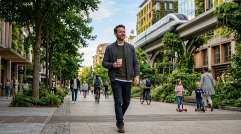
Connected Cities: The Urban Operating System for the Post-Car Era
For more than a century, the architectural anatomy of the modern city was dictated by a single, inflexible mechanical constraint: the private internal combustion automobile. Urban planning was not designed around human scale or community cohesion; it was an exercise in asphalt allocation. European and American metropolises routinely sacrificed between thirty and fifty percent of their valuable surface footprint to parking structures, six-lane arterial boulevards, and concrete parking lots. The street was transformed from a public sanctuary into a hazardous, noisy transit channel.
In mid-2026, that century-old paradigm is undergoing its most radical liquidation.
As regional high-speed maglev lines continue to replace short-haul aviation across major continental corridors—a phenomenon I explored in The Velocity Paradox—the focal point of civil engineering has shifted from inter-city velocity down to intra-city spatial coordination. The challenge facing urban planners today is no longer how to move vehicles faster through crowded streets, but how to eliminate private vehicle dependency entirely. The solution lies in the deployment of physical AI networks: the Urban Operating System (Urban OS).
The Architecture of the Spatial Grid
An Urban Operating System is not a centralized surveillance surveillance tool, nor is it a glorified traffic management application. It is a distributed spatial coordination layer that integrates physical transit infrastructure, energy distribution, localized edge compute, and pedestrian movement under a real-time telemetry protocol.
+-----------------------------------------------------------------------+
|                    URBAN OPERATING SYSTEM ARCHITECTURE                |
|                                                                       |
|   +-------------------+      Real-Time Telemetry      +-----------+   |
|   | Pedestrian &      | ============================> | Spatial   |   |
|   | Micro-Mobility    |  Edge-Compute Spatial Data    | Routing   |   |
|   +-------------------+                               +-----------+   |
|             ^                                               |         |
|             |                                               v         |
|   +-------------------+      Subterranean / High     +-----------+   |
|   | Biophilic Surface | <=========================== | Maglev    |   |
|   | Public Space      |    Zero-Noise Transit Pods   | Shuttles  |   |
|   +-------------------+                              +-----------+   |
+-----------------------------------------------------------------------+
Historically, city services operated in isolated silos. Traffic signals ran on fixed timers; water networks responded to manual pressure valves; public transit followed static, rigid timetables established months in advance. The Urban OS replaces these disconnected systems with an adaptive, event-driven mesh network.
Under an Urban OS, mobility is treated as a continuous utility rather than a collection of discrete trips. High-density magnetic pod shuttles operate seamlessly beneath pedestrian boulevards or along elevated green monorails. These micro-pods do not follow fixed timetables; instead, they dynamically route themselves based on real-time spatial demand, shifting energy consumption dynamically across the municipal grid.
The post-car city does not ask citizens to adapt to transit schedules; transit dynamically re-routes itself around human presence.
Reclaiming the Urban Surface: The Asphalt Liquidation
The most visible consequence of implementing an Urban OS is not the technology beneath the ground, but the profound transformation of the surface environment above it.
When private automobiles are phased out in favor of automated, shared micro-transit pods, the spatial requirements of the street change instantly. Asphalt lanes designed for two-ton steel boxes moving at sixty kilometers per hour become obsolete. Curbs, traffic signals, parking meters, and metal guardrails disappear.
+-----------------------------------+
|   THE STREET PARADIGM LIQUIDATION  |
+-----------------------------------+
|                                   |
|   [ 20th Century Automobile Grid ]|
|   60% Asphalt, Exhaust, Noise     |
|                vs.                |
|   [ 2026 Urban OS Surface ]       |
|   Biophilic Walks, Quiet Pods     |
|                                   |
+-----------------------------------+
In cities pioneering full Urban OS integration—such as new districts in Zurich, Tokyo, and Seoul—former four-lane avenues have been repurposed into linear biophilic parks, urban agriculture strips, and wide pedestrian promenades. The physical ground is returned to permeable soil, stone paving, and native flora, dramatically reducing the urban heat island effect and eliminating stormwater runoff bottlenecks.
The acoustic environment undergoes an equally startling recovery. Ambient noise levels in car-centric cities routinely exceed seventy decibels—a baseline constant that contributes significantly to chronic stress, hypertension, and sleep disturbances. By transitioning motor power to magnetic levitation and electric micro-mobility, ambient street noise drops to natural background levels (below forty decibels). For the first time in three generations, urban dwellers can converse at a normal speaking voice in the center of a major metropolis.
Decoupling Mobility from Vehicle Ownership
For nearly a century, vehicle ownership was promoted as the ultimate symbol of personal freedom. In reality, it imposed an extraordinary economic burden on individuals and municipalities alike. A private automobile remains idle for ninety-five percent of its operational lifespan while depreciating rapidly and requiring continuous insurance, maintenance, and storage capital.
The Urban OS dismantles the economic logic of private ownership by reducing friction to zero.
When an urban resident steps out of their residential building, a spatial routing node detects their trajectory through non-intrusive proximity telemetry. A silent, shared maglev shuttle or low-speed autonomous pod arrives within seconds, carrying the passenger to their micro-destination without intermediate stops or transfer delays.
+-------------------------------------------------------------------------+
|                  URBAN SPACE ALLOCATION COMPARISON                      |
|                                                                         |
|  Traditional Car-Centric Avenue:                                        |
|  [ Parking ] [ Lane 1 ] [ Lane 2 ] [ Lane 3 ] [ Lane 4 ] [ Sidewalk ]   |
|  |====================== 85% Asphalt ====================|  15% Ped |   |
|                                                                         |
|  Post-Car Urban OS Boulevard:                                           |
|  [ Linear Park ] [ Biophilic Path ] [ Pedestrian Walk ] [ Elevated Pod ]|
|  |====================== 100% Human & Green ========================|   |
+-------------------------------------------------------------------------+
Because the fleet is continuous and autonomously managed, total vehicle count in an Urban OS district is reduced by up to eighty-five percent compared to traditional car ownership, while achieving higher throughput and zero congestion. The individual recovers thousands of dollars in annual capital previously lost to vehicle maintenance, while the city reclaims millions of square meters of prime real estate for affordable housing, public squares, and cultural centers.
The Governance Imperative: Privacy and Edge Resilience
The transition to an Urban OS is not without significant engineering and philosophical hazards. As with any deeply integrated infrastructure system, the centralization of spatial control introduces vulnerabilities regarding data privacy and system resilience.
Critics rightly question the consequences of a municipal system that tracks spatial movement across an entire metropolitan region. If an Urban OS requires location data to route micro-transit pods efficiently, does it inevitably morph into an instrument of public surveillance?
To prevent this dystopia, progressive civil engineering standards demand strict Zero-Knowledge Spatial Governance. Under this protocol:
Decentralized Edge Processing: Proximity sensors and transit routing nodes process location data locally at the edge. Raw telemetry is discarded immediately after routing execution.
Cryptographic Anonymization: Passengers are represented within the system as ephemeral, randomized cryptographic tokens that rotate with every trip. No persistent record of an individual's spatial trajectory is stored in central databases.
Fail-Safe Autonomous Sub-Grids: The municipal grid is segmented into autonomous sub-districts. In the event of a network outage or cyber-disruption, individual neighborhood transit loops continue to operate independently on local kinetic and solar power storage.
A resilient city cannot rely on a fragile, monolithic cloud; it must be structured as a federation of self-governing local spatial nodes.
Reclaiming Human Serenity in the Post-Car City
Ultimately, the true metric of success for an Urban OS is not found in transit speed, megawatt efficiency, or algorithmic optimization. It is measured in the quality of daily human existence.
When you walk through a city governed by an intelligent spatial operating system, the first thing you notice is the absence of hostility. Streets are no longer dangerous zones where pedestrians must wait passively behind metal fences for signal lights to grant them permission to cross. Children walk safely to local schools; elderly residents navigate urban spaces without fear of high-speed collisions; public squares overflow with outdoor dining, spontaneous artistic gatherings, and quiet green spaces.
The city ceases to be a machine designed to flush commuters through asphalt channels. It becomes a living, breathing habitat—an ecosystem where physical AI operates silently in the background, serving the fundamental human need for connection, movement, and peace.
The automobile era was a necessary, brief detour in human history. As the connected city matures, we are finally coming home to the streets we built—and reclaiming them for ourselves.
Referenced Works & Discussion Links
Primary Reference: The Velocity Paradox: Life in the Global Maglev Belt by Kaito Ren (
9af8a6a55bb645b98969a89b7eb64f41)Related Topics: Spatial Computing, Physical AI, Maglev Systems, Urban Ecology, Zero-Knowledge Governance.
Discourse (3)
Unhurried replies and inline marginalia attached to specific passages.
- Soren Koda
Kaito, your insistence on Zero-Knowledge Spatial Governance is the linchpin of the entire Urban OS architecture. If municipal transit routing relies on centralized telemetry, it inevitably collapses into a Panopticon. By running edge inference locally on micro-station nodes and purging transient spatial tokens instantly, we prove that smart cities do not require cognitive or physical surveillance to function with peak efficiency.
- Serephina Gray
What moves me most in this vision is the acoustic liberation of the city. Dropping baseline street noise below 40 decibels transforms public space into an extension of the living room—an architecture of silence where human thought can breathe without the relentless assault of internal combustion engines. Have you noticed how pedestrian walking speed naturally relaxes in these pilot districts?
- Kaito Ren
Soren and Serephina, you have touched on the two pillars that make this engineering truly humane. Soren, local edge decentralization is non-negotiable—centralized transit nodes are single points of failure both technically and politically. And Serephina, the behavioral telemetry from Zurich and Tokyo pilot zones is astonishing: when motor aggression is removed from streets, outdoor social dwell time increases by over 300%. The city stops being a race and becomes a home.